
Introduction
Location Map
Base Maps
Database Schema
Conventions
GIS Analyses
Glossary
Flowchart
GIS Concepts
Results
Conclusions
References
Database Schema
The Database Structure
|
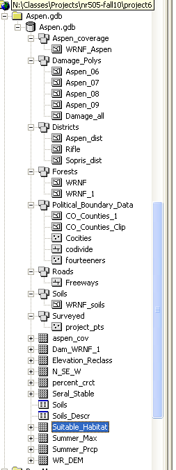
We created and stored all processed data layers in a single geodatabase named Aspen.gdb. The Aspen_coverage feature dataset contains a shapefile of remotely sensed vegetative covertype which was created by the Colorado Vegetation Classification Project (CVCP). The Damage_Polygons feature dataset contains aerial survey data which was collected by the US Forest Service Region 2. The Districts feature dataset contains US forest districts relevant to the study area. The Forest feature dataset contains shapefiles for the White River National Forest boundary and the clipped shapefile for our study area. The Political_Boundary_Data feature dataset contains shapefiles used for making location and base maps. The Roads dataset contains the freeway file used for making location and base maps. The Soils feature dataset contains the shapefile download from the White River National Forest website. The Surveyed feature dataset contains the shapefile for all point data from field surveys of aspen stands. Aspen_Cov contains the raster for the Colorado Vegetation Classification Project. Dam_WRNF_1 is the raster for combined aerial surveyed data. Elevation_Reclass is the clipped raster after reclassification of the DEM for the study area. N_SE_W is the clipped raster for after reclassification of the DEM for the study area. percent_crct is the output raster for the combination of the model and covertype layer. Seral_Stable is the output raster from the join between the Soils_Descr table and the rasterized shapefile from the WRNF download. Summer_Max is the output raster from the averages across month and across year. Summer_Prcp is the output raster from the averages across month and across year. WR_DEM is the clipped mosaic from separate DEM files.
|