Introduction
Location Map
GIS Concepts
Conventions
Database Schema
GIS Analysis Flowchart
Custom GIS Analyses
PHP Code
Base Map
Results: John Martin SWA
Results: Lower Gunnison
Conclusion
References
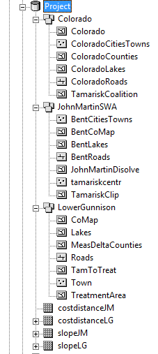
Geodatabase for the Project
Below are the features and raster datasets used for the project. The feature classes are listed under each of the three datasets; Colorado, JohnMartinSWA, and Lower Gunnison. The four raster datasets are unable to be moved into a dataset and are listed at the bottom of the geodatabase. CostdistanceLG and slopeLG were used in the Lower Gunnison dataset, and costdistanceJM and slopeJM were used for the John Martin SWA dataset. These four datasets were unable to be added, because they are rasters and not feature classes. To read more on the structure of geodatabases, Environmental Systems Research Institute (ESRI). For a better explanation of how the files were incorporated in the project review the analysis webpage.