Introduction
Location Map
Base Map
Database Schema
Conventions
GIS Analyses
Flowchart
GIS Concepts
Results
Conclusion
References
Case Studies in California Earthquake GIS Analyses:
Looking at relationships among risk, hazards and populated areas
By Liesel Hans & Krystal Tremblay
Contact Information: [email protected] and [email protected]
California is well-known for its abundancy of earthquake occurances. This is mostly due to the San Andreas fault line running along California's Western coast, with the potential to impact very highly populated and developed regions. There is a 99% chance of a big (magnitude 6.7 or higher) earthquake in Southern California within the next thirty years. With this in mind, there is an urgency for researchers and government officials to educate California's residents about earthquakes and what can be done to prepare for the future. There is a slow trend among residents to invest in earthquake insurance (for more information visit the California Earthquake Authority). There is still a significant lack in resident understanding of the epic damage that could occur with this next "big one". Building standards are being put in policy to help prepare for catastrophe. This project's goals are to educate about how risk is assesed and how a person might determine if they ought to retrofit their home or perhaps invest in earthquake insurance.
An example of a disastrous earthquake relatively recently was the 1989 Loma Prieta Earthquake:
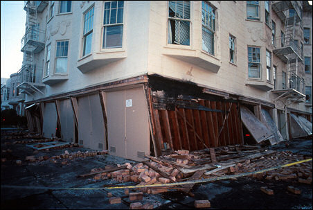

Top Left: Lack of adequate shear walls on the garage level exacerbated damage to this structure at the corner of Beach and Divisadero in the Marina District. Top Right: Officer peering into opening within the collapsed bridge; looking for survivors.
On October 17, 1989 a 7.1 magnitude earthquake "Loma Prieta" struck the greater San Fransisco Bay Area in California for only 15 seconds yet the devastation was extraordinary. There were 57 deaths directly caused by the earthquake, and six more deaths were ruled to be indirectly caused by the tembling. In addition, there were 3,757 injuries as a result of the earthquake. The highest concentration of fatalities, 42, occurred in the collapse of the Cypress Street Viaduct on the Nimitz Freeway (Interstate 880), where a double-decker portion of the freeway collapsed, crushing the cars on the lower deck.
The quake also caused an estimated $6 billion in property damage, the costliest natural disaster in U.S. history at the time. Pleas for assistance were answered in late October when President George H.W. Bush signed a $3.45 billion earthquake relief package for California. It was the largest earthquake to occur on the San Andreas Fault since the great 1906 San Francisco earthquake.
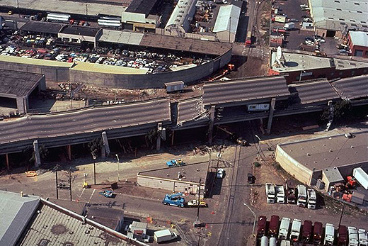
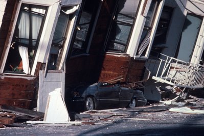
Top Left: The collapse of the Cypress Street Viaduct on the Nimitz Freeway (Interstate 880) where a double-decker portion of the freeway collapsed, crushing cars on the lower level. Top Right:An automobile lies crushed under the third story of this apartment building in the Marina District. The ground levels are no longer visible because of structural failure and sinking due to liquefaction.
Source: http://www.yuprocks.com/earthquake_pictures/loma_prieta_earthquake_2.shtml
Hazard Assessment in California
It is no secret that California is a tectonically active area and while predicting earthquakes is an ideal concept, it still remains beyond our grasp. Since prediction is futile and the occurence is inevitable the only advantageous concept is preparation.Earthquakes can be costly in terms of money but also lives therefore a correct assessment of the hazards in California is necessary to make critical decisions. It is important to identify the areas of highest risk and in order to do this factors such as fault location, slope stability, shaking -potential and liquefaction need to be taken into account. Better building codes for bridges and housing structures also need to be in place to ensure that structure failure such as that seen in the Loma Prieta earthquake doesn't happen again.
Background information on earthquakes and related topics discusses further in our project analyses:
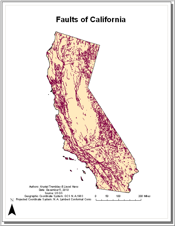
Faults
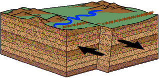
A fault is a type of fracture where blocks of rock on oppostie sides of the fracture have moved parallel with the fracture surface. i.e. Faults occur as the result of displacement of rocks along fractures. The figure above demonstates all of the faults that reside within California. Since earthquakes most often occur within these zones they are the central piece to any earthquake analysis. Perhaps the most well known fault in California is the San Andreas which is a strike-slip fault, meaning he blocks merely slide past each other as shown in the figure below.
Slope Stability
Slope stability is defined as the resistance of a natural or artificial slope to failure by landsliding. It is closely related to the geology (tectonic region, rock type) of the area. Generally, one of the most common triggering mechanism is strong vibrations from earthquakes.
ShakeMaps
A ShakeMap is a representation of ground shaking produced by an earthquake. This information is different because ShakeMap focuses on the ground shaking produced by the earthquake instead of the parameters describing the earthquake such as the magnitude and epicenter. Therefore, an earthquake can produce a range of ground shaking levels throughout a region depending on the distance from the earthquake, the rock and soil compositions, and the variations in the propagation of seismic waves from the earthquake due to complexities in the structure of the Earth's crust.
Whether the shaking of an earthquake is described in terms of the peak ground velocity, acceleration or spectral acceleration the information is still relevant to responding organizations. For instance, these shaking maps provide data to assess the scope of an event, or to determine which areas will be more/less affected (damaged/un-damaged). Thus, these maps are used in deciding where to allocate resources such as mutual aid to victims.
In addition, ShakeMaps are also formatted into GIS shapefiles in order to directly input this information into FEMA's Hazards U.S. (HAZUS) loss estimation software. This software is used by California's Office of Emergency Systems (OES) for assessing loss estimates as well as coordinating State and Federal response efforts. When these estimations are combined with maps of critical facilities (hospitals, police and fire stations), highways and bridges the OES can effectively prioritize their responses.
Lastly, ShakeMap shapefiles are also being used by power facilities (to assess areas that are more likely to be damaged), engineering, insurance and other institutions.
Source: http://earthquake.usgs.gov/earthquakes/shakemap/, http://pubs.usgs.gov/tm/2005/12A01/
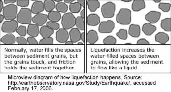
Liquefaction
Some soils are sensitive” in that a vibrating motion such as an earthquake causes them to lose their strength such as in the case of liquefaction. Liquefaction can only occur in saturated soils which are soils whose pore spaces are completely filled with water. The water exerts a pressure on the soil particles that influences how tightly the particles are pressed together. Water pressure is usually low before an earthquake however, earthquake shaking causes the water pressure to increase to the point where the soil particles can readily move with respect to each other. Since the grains no longer are in contact with one another there is a reduction in strength allowing the layer to flow. This can cause buildings to move laterally or sink into the liquified mass.
Source: http://www.ce.washington.edu/~liquefaction/html/what/what1.html
The United States Geological Survey (USGS) provides a plethora of information about earthquakes and includes community involvement features like the program "Did youfeel it?". This allows people who experience an earthquake to send the USGS their experience (how it felt, what was damaged, etc) to create a community shakemap. This helps inform residents about how others experienced the earthquake and helps the USGS improve their own instrumented shakemaps. Vist them at http://earthquake.usgs.gov/.
The California Earthquake Authority is a great resource for information about earthquake insurance: www.earthquakeauthority.com
An example of how professionals are trying to educate residents about earthquakes can be found here: www.earthquakecountry.info/roots/
Last Modified December 7, 2010.