Introduction
Location Map
Base Map
Database Schema
Conventions
GIS Analyses
Flowchart
GIS Concepts
Results
Conclusion
References
Database Schema
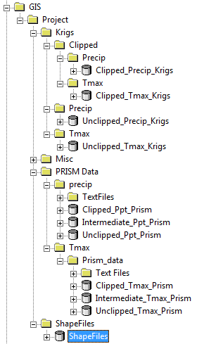
The “Krigs” folder contains all the rasters that were obtained from kriging the weather station data from YPG and WRCC. There are 12 rasters in the “precip” and “tmax” folders that have the "unclipped" geodatabases, each a square which encompasses all of the study area. After using Raster Calculator to clip the rasters to the study area, the 12 clipped rasters are in the “precip” and “tmax” folders which have the "clipped" geodatabases.
The folder “Misc” contains three .mxd files, meteorological data in .xls format, and the original .txt version of the weather station locations.
The “PRISM Data” folder has the projection rasters, resample rasters, and clip rasters for the precipitation and temperature data from PRISM. The "precip" folder contains the "clipped" geodatabase which has the 12 precipitation rasters which are clipped to the YPG boundary, the "intermediate" geodatabase which has the 24 projection and 12 resample rasters for the precipitation data, and the "unclipped" geodatabase which has the 12 original rasters for the precipitation data. The "tmax" folder contains the "clipped" geodatabase which has 12 maximum temperature rasters which are clipped to the YPG boundary, the "intermediate" geodatabase which has the 24 projection and 12 resample rasters for the maximum temperature data, and the "unclipped" geodatabase which has the 12 original rasters for the maximum temperature data.
The “ShapeFiles” folder contains shape files of the Yuma Proving Ground (YPG) weather station locations, the Western Regional Climate Center (WRCC) weather station locations, the outline of YPG, the outline of Arizona, and the outline of California, all seen in the location map and base map pages.