Introduction
Location Map
Base Map
Database Schema
Conventions
GIS Analyses
Flowchart
GIS Concepts
Results
Conclusion
References
![]()
Results
Results
Fire Density Analysis
A Kernel Density analysis was performed for each study plot site for each of the two properties. Each rectangle below represents the area of a study plot and the locations of fire scars within these plots. Some of the study plots had no fire-scar record, and therefore produced an overall density of zero. Otherwise, each of the rectangles below visually represents the density of fires recorded within the study plot using the Kernel Density function. The overall average of fire densities for each property can be visualized in Figure 3.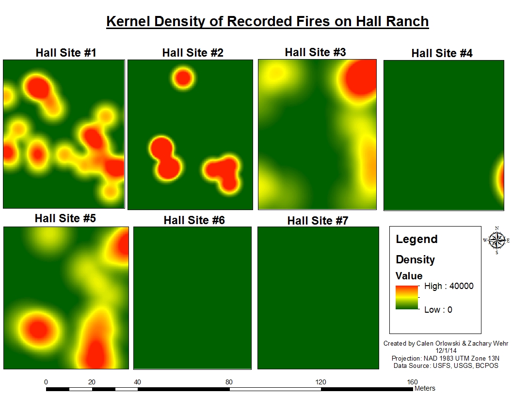 Figure 1: Kernel density of recorded fires on Hall Ranch.

Figure 2: Kernel density of recorded fires on Heil Valley Ranch.
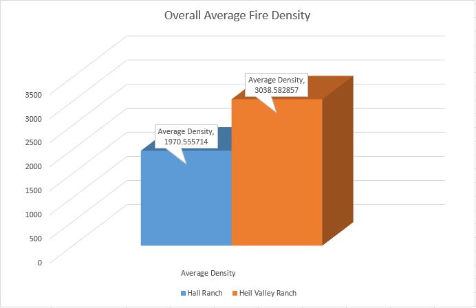
Figure 3: Overall average fire density of both properties.
Conclusion
Overall, there was a greater average density of fires recorded at Heil Valley Ranch compared to Hall Ranch that can be visualized in Figure 3. The kernel density analysis provided the average fire densities for each study site plot, and then these values were averaged for each property. Although Heil Valley Ranch had a greater density of fire over time, the study plots on Hall Ranch recorded a larger number of individual fire years throughout the analysis period. When the fire years were differentiated between pre-settlement (before 1859) and post-settlement (after 1859), there was a substantial difference in individual fire years that were recorded (Figure 4). Between the two properties there were 42 individual fire years for the pre-settlement era, while there were only 6 individual fire years for the post-settlement period. This analysis shows that direct and indirect effects of settlement were effective at stopping fires before they affected a larger-scale lanscape, and that fires had a larger spatial influence on the landscape in the pre-settlement era. The differences in this spatial influence can affect forest stand structure, tree spacing, and canopy cover area for these landscapes. It is important to mention that it is beyond the scope of our analysis and results to make any deductions regarding fire severity.
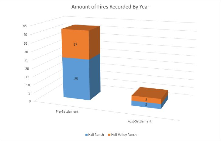
Figure 4: Comparison of recorded fire years for pre- and post-suppression periods.
Canopy Analysis
Canopy area was calculated at both ranch properties for all pre-settlement and post-settlement establishment trees. Each tree was buffered by a 3 meter radius to represent the crown of Ponderosa Pine (Pinus ponderosa). The boundaries between each buffered polygon were dissolved to faciliate the area calculation. The two figures below are graphically representations of each Ranch's study sites.
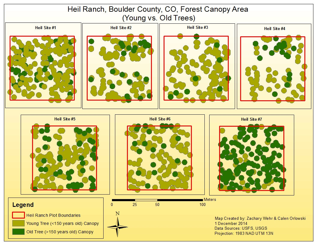
Figure 6. Young and Old tree canopy spatial arrangement at Heil Ranch.

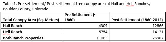
Figure 7. Total canopy areas Pre and Post-Settlement eras categorized by Ranch property
Conclusion
Overall, post-settlement (1960-2012) forest canopy area in our 14 plots were more than two times greater than pre-settlement canopy area values. Individually, both Hall and Heil Ranches had more than two times great post-settlement canopy areas than pre-settlement. These results demonstrate that fire suppression has resulted in increased canopy area due to higher amounts of successful regneration. These results convey that historically, the landscape survey areas of Hall and Heil Valley Ranches had much larger stand openings present.Cost Analysis
An analysis was performed for both ranch properties based of the costs associated with mechanical restoration treatments which serves the purpose of wildfire mitigation and a return toward HRV. The three chosen costs associated with treatment are: 1. Proximity to roads 2. Proximity to streams 3. Proximity to roads. The treatment cost maps are aimed at providing land managers with the general costs of treating various areas within Hall and Heil Ranches.

Figure 8. Proximity to roads treatment cost map for Hall and Heil Valley Ranches.

Figure 9. Treatment cost map based on slope for Hall and Heil Valley Ranches.
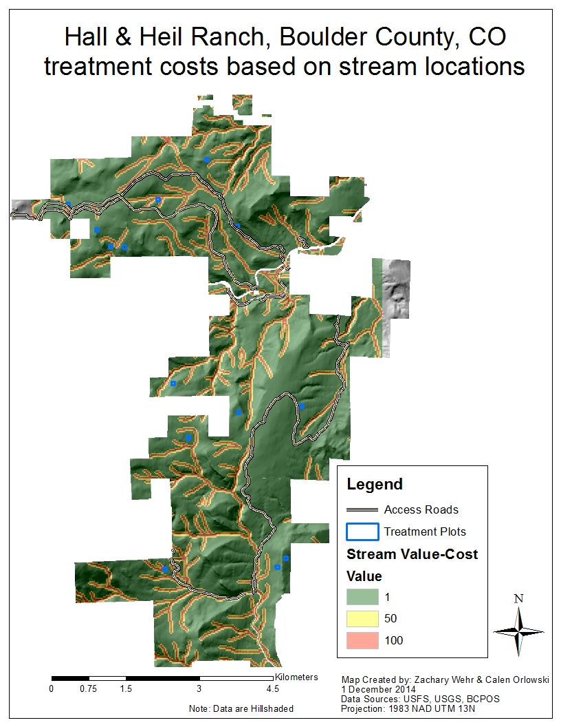
Figure 10. Proximity to streams treatment cost map for Hall and Heil Valley Ranches.

Figure 11. Total treatment cost map for Hall and Heil Valley Ranches using slope and distances to streams and roads.
Conclusion
Overall, both ranch properties have a large treatment area that is low-cost. The slope and distance to roads are the two most limiting costs associated with treatment. If Boulder County decides that streams cannot be crossed by mechanical equipment even if no treatment will occur in these riparian areas, the costs of distance-to-streams could be extremely limiting. Generally, both properties have many access opportunities for machinery, however, the slope will affect which stands are suitable for treatment (35% slope limit). There is also a large treatment area that is of medium cost values, which would be appropriate for treatment. If land managers prioritized fuels treatments evenly throughout their properties, there is only a small area where treatment cost are prohibitive.