Introduction
Location Map
Base Map
Database Schema
Conventions
GIS Analyses
Flowchart
GIS Concepts
Results
Conclusion
References
Database Schema
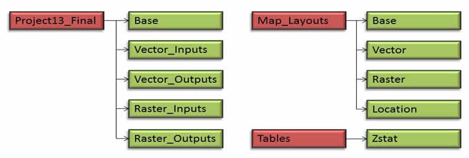
The schema adopted for data storage in this project was a personal geodatabase with feature datasets and raster catalogs. The Base, Vector_Inputs, and Vector_Outputs are all feature datasets. Within the Base feature dataset are data layers utilized by for the location and base maps. Within the Vector_Inputs feature dataset are vector feature classes, including roads, trails, recreation points, streams, and Insect & Disease Aerial Survey data. Within the Vector_Outputs feature dataset are vector feature classes, including the selected treatment stands and key intermediate products, such as stream buffers and excluded areas. The Raster_Inputs raster catalog includes the ASTER DEM and the Landfire Current Vegetation Cover product for the UNF. The Raster_Outputs raster catalog includes final and component GRIDs for management value, management cost, and management value-cost difference. The Raster_Outputs raster catalog also includes these GRIDs clipped to the extents of damaged stands for pixel-based priority analyses.
Map layouts were also organized within the Map_Layouts folder, with layouts for the Base map, the Vector analysis, the Raster analysis, and the Location map. Tables produced are stored in the Tables folder.