
Introduction
Location Map
Base Map
Database Schema
Conventions
GIS Data
GIS Processes
Flowchart
Results
Conclusion
References
Exploring Wolf Habitat Suitability in Washington State
Project Authors:
Mindy Clarke
Alia Dietsch
Danielle Ross-Winslow
Project Authors:
Mindy Clarke
Alia Dietsch
Danielle Ross-Winslow
| Grey wolves (Canis lupis) were listed under the Endangered
Species Act by the U.S. Fish and Wildlife Service in 1974 (2006) due to significant decreases in its habitat and
population size across the lower 48 states. Such protection status and reintroduction efforts have enabled wolves
to recover some of its historic habitat. Wolves are currently established in the Great Lakes region (i.e.,
Michigan, Minnesota) and the intermountain region (i.e., Idaho, Montana, Wymoing) and have started to recolonize
Washington state. Some residents are concerned that an increase in wolves could lead to problems like attacks on
livestock and population declines in certain hunted species. Others are excited about the prospect of having
wolves return to Washington (for example, the opportunity to see wolves in the wild). With this in mind, the
Washington Department of Fish and Wildlife (WDFW) has developed a wolf
management plan to address a myriad of concerns related to their arrival. Furthermore, the agency
partnered with human dimensions researchers from Colorado State University (CSU) to conduct a study
(Understanding People in Places, 2008) exploring residents' attitudes toward wolf management
in the state. PROJECT GOAL: This GIS project specifically explores habitat suitability for wolves in Washington. Using these results, we also explore how human dimensions data can be used to augment wildlife management decisions related to wolf recolonization of the state. |
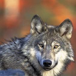 Photo courtesy of U.S. Fish and Wildlife Service |